AP was approached by PM&C for creative ideas on how to produce a video
that could outline the capabilities of the National Drought Map.
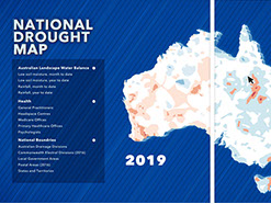
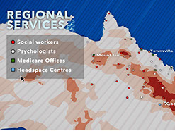
The National Drought Map is a complex interactive online map that combines datasets from a number of government agencies to ensure that drought responders have access to consistent information.
The original brief included sending the AP team to capture footage from drought-affected areas around Australia, however AP proposed a video based on motion graphic design and animation. This approach was adopted because it was able to communicate the capabilities of the map more effectively, it provided a large cost saving to the department and ensured that the tight deadline was met.
National Drought Map
Client: The Department of the Prime Minister and Cabinet


<
>
Close

© 2020 Copyright ASSOCIATIVE PRODUCERS PTY LTD